
© 2019 GIS Consulting Group, Inc.
Services
We offer a wide variety of services in the GIS market. Also, we are partners with Caribbean Aerial Survey, a local firm dedicated to orthophotography and photogrammetric products. Here are some examples:
Banking
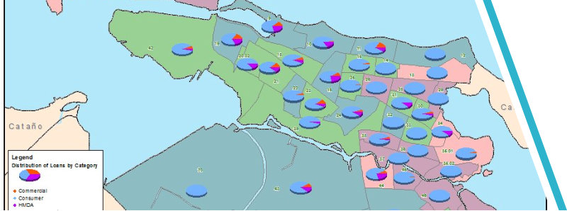
We provide services to major bank institutions in Puerto Rico, supporting them in compliance with the Community Reinvestment Act and the Home Mortgage Disclosure Act. We have the most extensive and up to date geodatabase of banks, lending facilities (consumer & Home Mortgage), Cooperative Institutions and automated teller machines locations. We also provide geographic distribution of small business and home mortgage loans, demographics and more. Through the implementation of different scenarios we can develop dispersion loan analysis, loan penetration & level of service, branch location and yearly deposits, in order to compare among institutions.

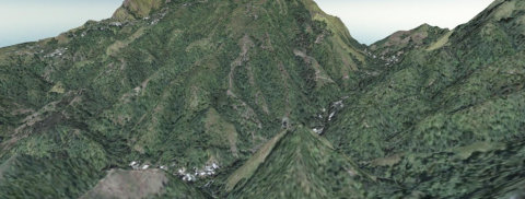
3D analysis
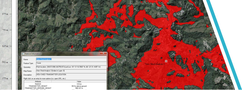
Using the latest technologies we have been providing tri-dimensional analysis for line of sight, coverage areas (cellular towers), optimum location and topographic profile. We are partners with Caribbean Aerial Surveys, a local firm dedicated to photogrammetric and surveying products. Together we offer a complete solution on location and expansion analysis for radio transmitters, cellular, and microwave towers. The analysis, not only includes the coverage, but with the demographic data, we can provide the client, with detailed data regarding actual or potential customers.


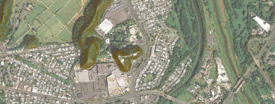
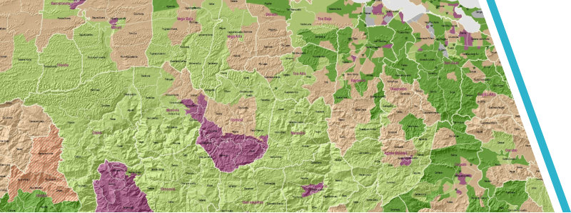
Urban & Environmental Planning
Preparation of all related cartography and database compilation for municipal land use plans. Geodatabase design which includes; infrastructure, landmarks, road network updates, topography, general photogrammetric data among others. Cartographic design following conventional standards. Brownfield & Municipal Separate Storm Sewer System Program (MS4) design and management, including project management, data compilation and report presentation. Environmental Impact Statements (EIS) – Design of geodatabases and field data compilation for EIS. Spatial analysis in order to determine possible impacts on population, endangered species, natural areas, etc.

Demographic Analysis
We create custom analysis using the most recent census data available and historical analysis using data up to 1980’s census. We provide socioeconomic studies providing a valuable tool for new developments, store location, necessity and convenience certificates (health facilities).


Urban & Environmental Planning,
Geographic Information Systems

© 2016 GIS Consulting Group, Inc.
Services
We offer a wide variety of services in the GIS market. Also, we are partners with Caribbean Aerial Survey, a local firm dedicated to orthophotography and photogrammetric products. Here are some examples:
Banking
We provide services to major bank institutions in Puerto Rico, supporting them in compliance with the Community Reinvestment Act and the Home Mortgage Disclosure Act. We have the most extensive and up to date geodatabase of banks, lending facilities (consumer & Home Mortgage), Cooperative Institutions and automated teller machines locations. We also provide geographic distribution of small business and home mortgage loans, demographics and more. Through the implementation of different scenarios we can develop dispersion loan analysis, loan penetration & level of service, branch location and yearly deposits, in order to compare among institutions.

3D analysis
Using the latest technologies we have been providing tri-dimensional analysis for line of sight, coverage areas (cellular towers), optimum location and topographic profile. We are partners with Caribbean Aerial Surveys, a local firm dedicated to photogrammetric and surveying products. Together we offer a complete solution on location and expansion analysis for radio transmitters, cellular, and microwave towers. The analysis, not only includes the coverage, but with the demographic data, we can provide the client, with detailed data regarding actual or potential customers.


Urban & Environmental Planning
Preparation of all related cartography and database compilation for municipal land use plans. Geodatabase design which includes; infrastructure, landmarks, road network updates, topography, general photogrammetric data among others. Cartographic design following conventional standards. Brownfield & Municipal Separate Storm Sewer System Program (MS4) design and management, including project management, data compilation and report presentation. Environmental Impact Statements (EIS) – Design of geodatabases and field data compilation for EIS. Spatial analysis in order to determine possible impacts on population, endangered species, natural areas, etc.
Demographic Analysis
We create custom analysis using the most recent census data available and historical analysis using data up to 1980’s census. We provide socioeconomic studies providing a valuable tool for new developments, store location, necessity and convenience certificates (health facilities).